NORTHERN TSHWANE: WINTERVELD
Situated on the north-west border of Gauteng province, Winterveld is an interesting case study site, offering insight into this region’s deep history; the ambiguity of the urban-rural divide; and the complexity of understanding the nexus of poverty, infrastructure and access.
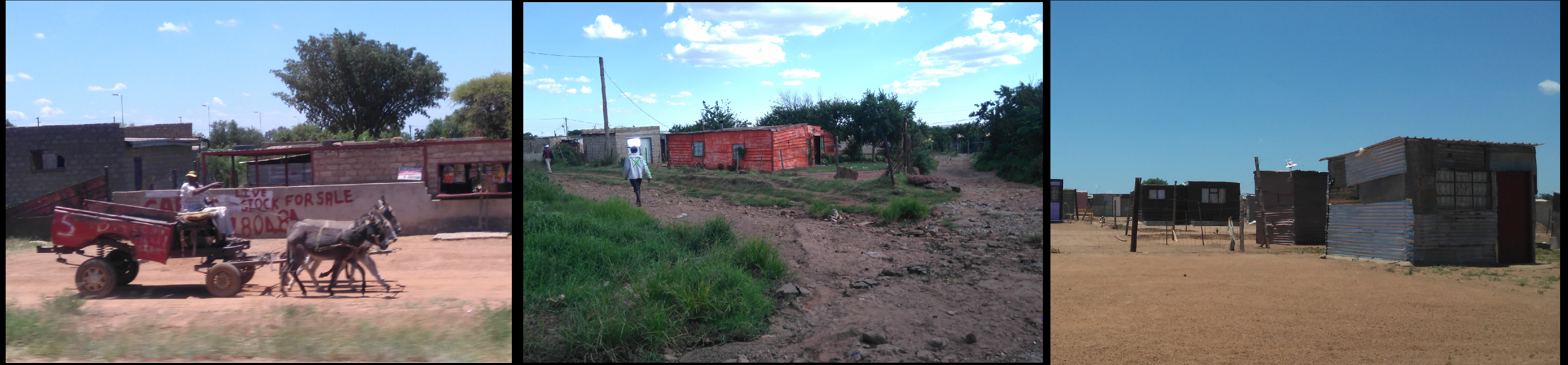
Historically, Winterveld served as an apartheid relocation settlement, hosting black people forcibly removed from Pretoria. The area, which spans 120km2, was part of the rural ‘homeland’ of Bophuthatswana, despite its 40km distance from the capital. It is part of a broader belt of dense settlements which once fell under homeland rule, but relied largely on long-distance commuting into Pretoria for employment. Some homeland industrial decentralisation points were created in this broader region, with varying levels of success.
While much of Winterveld is sparsely populated with moderate population growth – following a period of decline – there are dense pockets of informal settlements. Despite the rural feel, the area is fundamentally tied to the urban economy, with agriculture largely being a short-term or ad-hoc livelihoods solution (SACN 2015).
A Special Presidential Lead Project under Mbeki, the site has received significant state investment in housing, electrification, schooling and other services. The area offers residents cheap accommodation and potentially significant social networks. However, there are still high rates of crime and poverty; limited employment opportunity; and long, costly commutes to urban centres. These quotations reveal the contradictory nature of Winterveld today:
Objective measures of poverty may make Winterveld no more poor than many other South African rural communities, yet the fact that it is so linked to the urban economics of Greater Pretoria escalates the costs of living, diminishes the viability and value of practicing a more rural-oriented livelihood, and thus increases the experiential intensity of poverty. - Simone (2004, p.68)
Despite evidence of remnants of the apartheid legacy, post-apartheid policy for Winterveld has significantly redressed apartheid spatial planning patterns and has led to improved access to services and infrastructure in Winterveld since its incorporation into the municipal area of the City of Tshwane in 2001. - Ntema and Van Rooyen (2016, p. 136)
Our study in 2017 found that although there was evidence of state investment in housing, and services in some areas of Winterveld, many residents’ everyday experiences were of persisting poverty, although there was evidence of entrepreneurialism for some. Reasons for significant poverty are complex. The wider area still contains many undeveloped and very marginal areas, which have a rural feel in terms of isolation, land use, lack of services and lack of regular waged labour. The peripheral sub area of Checkers typifies this, and residents complained of very poor access to water. Our studied noted that there were evident peripheries within the wider urban periphery. In contrast to many of our other case study areas, the wider Winterveld case contained far larger plot sizes, consistent with its rural history. These plots facilitated the practice of subdivision, often illegally, in order to lease land for housing. These arrangements complicate the servicing of these areas, with tenants accessing services illegally. There was evidence of densification and that this area played a role in attracting and supporting new migrants aiming to establish a foot hold in the ‘nearby’ city of Tshwane. Our study found that there is an informal area immediately adjacent to Winterveld which is dominated by ‘strong men’ who control access to land, housing and services, particularly electricity. At times their control is aggressive and problematic.