Data, the 4IR and spatial transformation in Johannesburg
- Miriam M. Maina
The Fourth Industrial Revolution (4IR) has been lauded for its potential to accelerate global social and economic transformation, raise income levels, and improve the quality of life. The 4IR is distinguished from previous industrial revolutions by increased fusion of technologies and the blurring of lines across the physical, digital and biological spheres. This has been driven by developments in technology and computing, most notably the expansion of processing power and storage capacity, enhanced connectivity and networks, increasing access to information and collaboration, and technological breakthroughs in AI, robotics, IoT, automation, biotechnology, quantum computing, large-scale information and big data, and analytics.
The effect has been the reorganisation of nearly all industries and sectors across the world, through the transformation of systems of production, management, governance, and all aspects of social and community life.1
While the 4IR holds great potential for enhancing productivity and efficiency, transforming sectors including healthcare, finance, mobility, and sustainable development, and driving the emergence of new markets; 4IR is not without challenges. ‘Datafication’ refers to the logic and processes through which subjects, objects, and everyday life are turned into digital data. This data is increasingly mined for value, or applied in governance, policy, and legislation. Critical engagement with developments in this field have highlighted the scope for this to contribute to expanding inequality.
Leveraging 4IR (and data) for sustainable development and spatial transformation
The 4IR transition marks a moment of transformation across government, businesses, and society. How can governments and institutions leverage 4IR’s potential to drive social, spatial, economic transformation? There is a need for governments to be responsive and adaptive, to leverage rapid technological change towards achieving development aspirations and enhancing human development, economic competitiveness, and transforming human settlements.2
This will require the expansion of the capacity and capability of all institutions and stakeholders to harness the potential of 4IR and apply it to developing solutions for local contexts. At the local level, there is an increasing need for interactive, collaborative decision making and mutual
learning across government, industry, civil society and residents. One of the key drivers of the 4IR is big data and analytics. Sometimes described as the ‘new gold’ or ‘new oil’ of the 21st Century, data underpins the majority of the technological dynamics in AI and digitalisation, and has transformed decision making and business models across industries. With this transformation has come the need for the formulation of national policies on data, data protection and data access.3
As in other sectors, urban development and spatial planning have been transformed by developments in 4IR, and through rapid technological change across sectors and industries related to the production of space. An emerging research thread will be on how urban data and analytics is applied in policy-making and in the legislation and coordination of urban investments in land use, infrastructure and utilities, transport and mobility, and human settlements development, particularly in cities in the developing world.4
Blog series
SA&CP and NOVAYA Labs will be publishing a 4-blog series on data, spatial planning, and public and private sector investment for sustainable urban development, focusing on the Johannesburg Metropolitan Municipality.
The blogs will explore how data has been used to drive strategic spatial planning, integrated development planning and investment from within the Metro.
They will also track developments in open data in Johannesburg and South Africa, and how urban data has been leveraged by the private sector and civil society in South Africa.
Lastly, the blogs will explore emerging research and investment opportunities created by applying data and plantech for strategic spatial planning, and the coordination of investment resources for urban development.
Dr Miriam Maina is an urban researcher, GIS and spatial analytics consultant and a post-doctoral researcher at the NRF Chair in Spatial Analysis & City Planning. This blog post first appeared on One City.
A Multi-level Perspective on Data-Driven Spatial Transformation in Johannesburg
- Peter Magni and Miriam Maina
This blog uses a ‘multiple level perspective’ as a prism through which to view processes of urban transformation.
Fixing Cities
Rapid urbanisation is acknowledged as a cause and manifestation of the world’s current environmental challenges. Creating a more sustainable global future will require creating, transforming, or retrofitting existing urban systems to achieve social, environmental, and economic sustainability.
This blog uses a ‘multiple level perspective’ as a prism through which to view processes of urban transformation. This perspective sees change being initiated in ‘niches’ such as organisations or locales, which must be accepted by the existing ‘regime’ - a local government, or a multinational company. This takes place in the context of wider ‘landscapes’, which include national to trans-national policies and processes; networks such as social movements; and events, such as a pandemic.
OneCity as Niche Enterprise
We view OneCity as a locally attuned (or ‘niche’) enterprise that empowers property investors and developers with analytics and information to unlock development. OneCity consolidates urban data on a single platform, providing city planners and other urban investors with information and analytics to inform investment and development decisions. The tool works with the City’s spatial aspirations and policies which are geared towards driving efficient and sustainable spatial transformation, and creating a compact, polycentric city that is well connected through efficient public transport.1
The Johannesburg Context
The City of Johannesburg is the local ‘regime’. As the sphere of government responsible for local planning, the City is responsible for land use planning, management, and coordination of public infrastructure investment at the local level. The City is constantly transforming and shifting it’s policies, processes and legislations, in response to ongoing challenges and mandates. As a regime, the Metropolitan authority is continually changing, and the changes adopted depend on how ‘niche’ solutions such as OneCity correspond to the City’s objectives.
South Africa’s Data Landscape
The ‘landscape’ in which OneCity supports urban transformation includes South Africa’s economic outlook, the dynamics in the property development and investment sectors, and local government spending strategies.
But perhaps the most influential aspect of our landscape is the data environment, and how the city adopts and implements changes in technology, data regulation and administration, in order to develop robust and relevant solutions to urban challenges.
In the last few years, South Africa has shown a positive trend in developing policies seeking to guide the generation, management, and sharing of data for innovation and development. Similar progress is also evident in Metro authorities adopting open-data strategies. We will look at these trends in subsequent blogs.
In the next blog, we will focus on how Johannesburg uses urban data for coordination, strategic visioning and planning, infrastructure investment, and spatial transformation. And we will see where OneCity and other technologies fit into this picture.
Urban Data Trends, Challenges and Opportunities in Johannesburg
- By Peter Magni with thanks to Miriam Maina
This is the third blog on the series on data, spatial planning, and public and private sector investment in the City of Johannesburg.
How the City generates and manages data
Managing a large city such as Johannesburg requires a significant volume of data and subsequent analysis of this data, for the coordination and management of land use, and the provision and operation of public infrastructure. Some data is needed to manage specific tasks, such as running a wastewater treatment plant. Some are necessary for long-term city planning; for example, population change and gross value added. The city needs urban data at varying degrees of detail and it needs to be collected longitudinally, to monitor and analyze trends over time. To obtain, manage, and extract value from this data, the City deploys multiple strategies.
The city generates the bulk of urban data internally, through its day-to-day activities. In some instances, this data is collected manually, and then transferred to digital databases. In the majority of cases, the city data is generated and stored internally on internet-accessed operating systems designed specifically to fit each purpose. Johannesburg’s Municipal Owned entities (MOEs), including City Power, Joburg Water and the Johannesburg Metropolitan Police Department (JMPD) also run real-time monitoring systems and technologies within their specific mandates. These systems generate data that requires specialist knowledge to offer general and specific analysis. The trend over the last twenty years has been to facilitate immediate capture and sharing of data within departments.
This section describes some of the existing ways in which City data is used internally in the City of Johannesburg to drive policy and decision making and so sets us up to consider some of the emerging opportunities and challenges for data collection and use in the City.
Data generated and managed by the City of Johannesburg is used to inform policy, decision making, and investment within and across departments. Examples include the Johannesburg Strategic Infrastructure Platform (JSIP) which supports the prioritisation and coordination of capital investment in the city, a SAP-based system of financial management and reporting, and the Land Information System (LIS) which tracks property information, development applications, and investments, and which underpins strategic spatial planning.1
Strategic spatial planning Johannesburg’s Spatial Development Framework (SDF) sets out the spatial policies for the metropolitan region, identifying strategies through which these spatial visions could be met. At the sub-metropolitan level, these policies are detailed in Regional Spatial Development Frameworks (RSDF) and precinct plans. The city’s current SDF aspires to create a ‘spatially just city’ which is envisioned as a ‘compact polycentric city with a dense urban core linked by efficient public transport networks to dense, mixed-use, complimentary sub-centres, situated within a protected and integrated natural environment.2
This spatial framework defines and identifies priority transformation areas which, when linked to the City’s capital investment prioritisation model (JSIP), would promote, prioritise and target public and private sector capital investment into these areas.
Capital investment planning and prioritization
The existing system of capital investment prioritisation and management is the Johannesburg Strategic Infrastructure Plan (JSIP), which is managed by contracted private sector consultants. The platform is a web-based tool which allows staff responsible for infrastructure projects across the city to capture their capital needs and locate the project on a geographical information system. Projects are prioritised based on this information through a series of technical and political meetings, through which the city's capital budget is finalised.
Another aspect of capital budgeting and investment in the city relates to the refurbishment and replacement of existing infrastructure. This is outlined in the City’s infrastructure asset management plans which are maintained by each of the departments and municipal-owned entities. The sophistication of the information systems underlying these management plans varies from department to department. However, with increased emphasis on the need to increase maintenance budgets and the influence of National Treasury’s City Infrastructure Delivery Management System (CIDMS), which seeks to rationalise urban services provision and optimise performance across the urban infrastructure value chain, there has been greater consideration of infrastructure asset management over strategic spatial targeting in the City.
Financial investment management and reporting
Although strategic spatial planning and infrastructure asset management are critical, it is the City of Johannesburg’s financial system that ultimately determines how investment occurs. This constitutional mandate is provided in the Municipal Finance Management Act, which lays out the norms and standards for financial management and reporting. Johannesburg’s financial management system is coordinated through a SAP-based information system, which manages revenues, expenditure, and reporting. This platform is highly sophisticated, although it is limited by cost, and by the complexity of the metropolitan administration.
The platform has been refined over the last two decades, and has therefore developed its own robustness, familiarity and inertia. And though it allows for limited public scrutiny and input, it is also prone to political influence both from elected and administrative officials. Aggregated data generated from this city’s finance system can be publicly accessed via Municipal Money, an open data initiative from South Africa’s National Treasury, which allows review and analysis of Municipal financial data over time.
Trends, challenges, and opportunities
The previous section presents some of the existing systems through which City data is used internally in the City of Johannesburg to guide spatial, infrastructure, and financial analysis, prioritisation, investment decision making, and reporting. Though this list is not comprehensive, it shows how urban data is used internally to drive policy and decision making. This section identifies some of the emerging opportunities and challenges that currently exist.
A first concern is that the various systems and technologies developed for the city to collect, manage, and utilise its data are developed by private consultants, hosted through proprietary platforms, and operated by the City’s staff. Over time, these could prove expensive to run and upgrade; becoming obsolete quickly as new technologies keep being developed. This approach nonetheless ensures a sense of security, reliability and quality of service.
An emerging trend in the last decade that has affected urban data use in the city has been the outsourcing of policy and planning work to private companies. This has removed the internal incentive to develop and maintain data systems. The continued outsourcing of operational and capital projects has meant that less of the primary data is engaged directly by city employees, with the effect of ‘hollowing-out’ the City’s own data management and analysis capacity. This could prove challenging, with increased reliance on complex and data-informed decision making processes.
Integrated planning and investment requires the sharing of data and information across departments. While collaborative data sharing and decision making has been achieved internally, this information is not unreservedly shared with the public, or private sector agencies. This is because data is still viewed as being personal to departments, or sensitive for the functioning of specific networks. This sensitivity to share data can be seen as the reason for the persistent reluctance to facilitate an open data portal.
This blog highlights the developments in the collection, management, and use of urban data in the City of Johannesburg in the last few decades, presenting some of the existing data-driven platforms and processes. This data is used internally for planning, policy making, and investment coordination, and externally, for reporting to the public and in compliance to National government departments. There still remains considerable potential that this City data could be shared and used by a wider range of stakeholders, and for the development of analytical tools, systems and platforms in the private sector, and for the public domain.
In the next blog, we will explore how municipal and other urban data in Johannesburg and South Africa has been shared and used in the private sector, by NGOs and the general public.
Urban Data and Analytics: emerging opportunities in Johannesburg and South Africa
- Peter Magni with thanks to Miriam Maina
In this blog, we explore developments in Johannesburg and South Africa relating to the use, re-use, and application of urban data.
We live in an era of abundant data, but inequities and asymmetries in accessing this data have considerably stunted the collective capability to apply and re-use it for positive change. In this blog, we explore developments in Johannesburg and South Africa relating to the use, re-use, and application of urban data.
In previous blogs, we demonstrated how urban data is generated, utilised and shared internally in the City of Johannesburg to support planning, investment, and decision making, as well as for reporting and documenting impact. The South African data ecosystem also comprises private-sector data suppliers. These often provide data, analytics and information in cases where the public sector does not provide data, or when the data requires specialist analysis. Examples of commonly used private data and analytics companies include: GeoterraImage, IHS Markit, Lightstone, Quantec and Municipal IQ. Certain research institutes such as the South African Cities Network (SACN) and the Gauteng City Region Observatory (GCRO), especially its Quality of Life surveys, also provide high-level urban data to city governments.
Open Data Developments in South Africa
City governments around the world have implemented the principle of sharing city data as a civil right through online open data platforms, with varying success e.g. New York, Raleigh NC, Nairobi. Where stable open data platforms and communities have been established, the successful use and re-use of public (and private) data have produced collaborative data partnerships and communities. These have been able to extract insights, analysis and value from data, and develop new products, technologies and insights.1 South African cities and municipalities, however, have been relatively slow to embrace open data. In 2015, the South African Cities Network (SACN) developed the South African Cities Open Data Almanac (SCODA) with the open data advocacy NPO Open Data Durban, now known as Open City Labs (OCL). SCODA was intended to be a website where city municipalities could contribute data either as a regular data dump or in real time. This did not happen as planned, and the platform today primarily maintains SACN generated data and reports.
Durban shoreline, South Africa. Photo by Jason Briscoe.
Some reasons for the platform’s limited use include it being external to municipal control; the lack of defined objectives to host specific datasets; and concerns that data would be misused or used for commercial purposes. Without the support of participating municipalities, the two NPOs did not have the financial resources or buy-in to realise SCODA’s initial intent. Additional reasons for the reluctance to adopt open data at the time included political considerations, concerns over the government’s data liability, the existing relations between the private and public sector concerning data, and distrust of big data techniques because of a dearth of related skills and fear of redundancies. Furthermore, as open data in South Africa has been championed by NPOs there is an idealistic bent to existing initiatives, such that they have not explored the commercial potential of open data and how the private sector might derive benefit from such initiatives.
There have been subsequent metro-led open data initiatives since, though the scope and impact of these have remained limited. Examples include eThekwini Municipality’s Durban Edge Open Data Platform. Established in 2011 by the City’s Economic Development Unit, this platform provides datasets, economic and multi-sectoral analysis and insights in publications and through interactive, analytical dashboards. Arguably a more successful open data platform is the City of Cape Town’s open data portal. The portal currently offers 146 datasets; primarily spatial data, but also data relating to such diverse topics as air quality, budgets, business licenses and wastewater discharge. The platform’s success can be attributed to the City taking responsibility for the data that is accessible on the platform. The data is also regularly updated and has continued to improve over time, creating a portal that is trusted, internally and externally accessible, and easy to use.
Similar factors have contributed to the success of other South African open data platforms such as Municipal Money, a National Treasury Website providing Treasury data concerning municipal finances and the South Africa Data Portal by Statistics South Africa, which also provides high-level data sets.
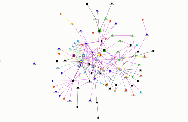
It can be argued that despite the abundance and availability of data, there remains a reluctance to adopt and embrace open-data platforms in South Africa, particularly at the municipal level. An initiative by the South African Cities Network (SACN) and the South African Council on City Data (SACCD) to identify and map actors, initiatives, and stakeholders in urban data presents a picture that is mainly dominated by government agencies, and a few established private sector and academic data providers.
Stakeholder Map from the South African Council on City Data. Image credit: SACCD stakeholder mapping
Conclusion
The open data movement has progressed from a first wave, which focused on securing the freedom of information; through a second wave, within which governments and organisations provided open data, deepening transparency. In the current ‘third wave’, focus has shifted to greater collaboration, sharing
and re-use of both public and private-sector data for ‘evidence-based policy making, innovation, and value creation’.2 This requires data stewardship within organisations, concerted capacity building, legislative and regulatory shifts, and the establishment of technologies and systems that allow for data use and re-use within an environment of responsible and ethical data use. There have been considerable shifts in South Africa, most recently with the production of the National Data and Cloud Policy which promises the development of a National Open Data Strategy. The continued development and establishment of open data portals within national and local government departments is also encouraging.
This is the final blog in our series on data, spatial planning, and public and private sector investment in the City of Johannesburg.
Data, Analytics and Spatial Planning in Johannesburg: Emerging Opportunities
In tracking the evolution of the ‘open data’ movement, sector experts at the Open Data Policy Lab propose that we are entering a ‘third wave’ of open data, which can be distinguished from the two previous waves by scale, scope, stakeholders involved, and potential applications.
In the first wave, data was shared on request, based on a ‘right to know’ basis. This demand was mainly driven by journalists, lawyers and activists, and has resulted in Freedom of Information legislation and policies to unlock data.
The second wave grew out of this movement and with developments in Web 2.0, with the embracing of open-data policies at the National and International levels. The data audience expanded to civic technologists, government agencies, corporations and tech startups. However, the Data shared was predominantly open government data aggregated at the National level. A distinguishing factor in this phase was that data was disbursed by default, without a clear understanding of how it would be applied.
The third wave of open data anticipates a more purposeful and purpose-driven approach to open data:
“it seeks not simply to open data for the sake of opening, but to focus on impactful re-use, especially through inter-sectoral collaborations and partnerships. The Third Wave pays at least as much attention to the demand as to the supply side of the data equation; and the way its use impacts the public-at-large. It is concerned not simply with data itself but with the broader technical, social, political, and economic context within which data is produced and consumed.”1
These developments in open data call for shifts in governance and technical capacity of actors in both the public and private sectors, increased collaboration, and strengthened accountability mechanisms to support a rights-based data reuse environment.
They push for a partnership and collaboration based model, which requires solid governance frameworks and regulatory clarity, as well as the establishment of common data sharing agreements and licensing regimes.
This phase also calls for a greater number of stakeholders, and the rise of data intermediaries, and greater accessibility and findability of high value datasets.
They advocate for bolstered public competence and the strengthening of accountability mechanisms, to support rights-based data re-use.
To create the technical infrastructure for re-use at the local level, there is a need to invest in Subnational Capacity, Guidance, Legal Frameworks and the development of best practice.
They call for actors in both public and private sector agencies and organisations to overcome the tendency towards data protectionism, and the establishment of an infrastructure system that protects privacy while boosting innovation.2
There is also a need to document and experiment with different operational models that are “fit for purpose”, and to articulate value and build an evidence base of the impact of data re-use for public interest purposes.
Global and local policy shifts
At the global level, we’re observing the development of strategies and policies to enable actors to tap into the opportunities presented by data, cloud computing and digital economies. This includes the promotion of data as a strategic asset, whereby various countries are enacting data protection laws and policies to support a rights-based data ecosystem.
In the case of South Africa, data is present and plentiful but its access and usability have been hampered. This said, recent policies and legislation in the country have begun to cater for the realities posed by data and the digital economy, and to structure the environment for data-driven decision making.
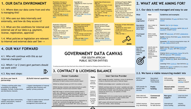
In a previous blog, we highlighted the ongoing efforts to implement open data approaches at National and local governments. In addition, the South African government has formulated the National Data and Cloud Policy, which proposes the development of a common ecosystem through which data and digital technologies will be coordinated within the country. The policy seeks to:
Remove regulatory barriers to promote connectivity and access to data and cloud services, and enable competition;
Provide for institutional mechanisms for the governance of data and cloud services;
Support the development of small, medium, and micro enterprises (SMMEs); and
Provide for research, innovation, and human capital development.
Alongside these policy shifts, there are also notable developments with the continued dissemination of sub-metropolitan data, and the rise of urban-innovation hubs that bring together actors from the metropolitan administrations, research and academia, and the tech and innovation sector.
Research opportunities
Through this project, we have identified research and innovation opportunities centred around the use and application of data and analytics in the coordination of urban planning and investment projects in pursuit of various sustainable development agendas. These are as follows
Data-driven urban analytics and platforms: As presented in our first blog, emerging digital tools like OneCity occupy a niche space in the urban development sphere. This is because their potential to combine multiple data sources and analytics into a single platform enables greater synchronisation between spatial planning aspirations with property developers’ investment goals. Such a platform could deepen collaborative planning, expedite development processes, and over time, increase the likelihood of achieving spatial transformation and sustainable development goals. There are opportunities for research in tracking the efficacy of deploying this and other platforms with a revenue-earning component within a South African context over time.
Planning, investment, and property market intelligence platforms and methodologies: In addition, it may be useful to compare the OneCity methodology to existing methodologies and spatial analytics platforms prevalent in South Africa, both within the public and private sector.
Though the plantech and proptech sector in South Africa is still in its emergent stage, it would be critical to assess the property market intelligence available to the private sector in Johannesburg, and the methodologies used to capture and analyse data. Additional inquiry could explore how current private sector data providers and analytics service providers currently meet the demand of property developers, and existing gaps in this field.
From the public sector, there are opportunities to explore theintersection of data, integrated planning and proptech for coordinated investment and sustainable development in South Africa. This would include documentation and exploration of the efficacy of platforms and technologies such as the investment prioritisation model used in the Johannesburg Strategic Infrastructure Platform (JSIP), methodologies used in the City Nodal Review Policy, or the methodologies proposed in the Cities InfrastructureDelivery and Management Systems.
Modelling urban infrastructure accessibility: The benefits of improved infrastructure accessibility in relation to public transit and non-motorised transport (NMT) need to be modelled and illustrated for Johannesburg.Adopting data and evidence-led analysis of the impact of public transport and mobility investments on accessibility, and on the achievement of the city’s spatial transformation goals would strengthen the case for the adoption of open data standards, and for a data-driven approach to measuring and evidencing urban change.
Monitoring data-driven urban transformation and coordinated investment: Another key area for continued exploration is the ‘regime’ in relation to land use management and public infrastructure investment - in the case of Johannesburg, the Metropolitan Municipality. Here, there is a continued need to investigate how analytical tools like OneCity can enable planning authorities to: realise objectives defined in the spatial development framework; and to improve the turn-around time for development applications for both public and private sector development applications. Researchers could also track how effectively the transition to a more sustainable infrastructure provision is being coordinated, with an emphasis on public transit and non-motorised transport.
This blog series has mapped out the research and innovation opportunities surrounding the use and application of data and analytics in the coordination of urban planning and investment projects in pursuit of various sustainable development agendas. OneCity advocates for continued adoption of open data standards, and the transition to the third wave of open data, towards collaboration, partnership, and innovation - as these would enable a transition to enable more efficient spatial transformation and equitable urban development.
Open Data Policy Lab. (2020). The Emergence of a Third Wave of Open Data: How to accelerate the re-use of data for public interest purposes while ensuring data rights and community flourishing. New York: GovLab. Retrieved from https://opendatapolicylab.org/third-wave-of-open-data/
Kay, L. (2019, June 20). Why data protectionism will make us all poorer. Retrieved from Apolitical: https://apolitical.co/en/solution_article/why-data-protectionism-will-make-us-all-poorer