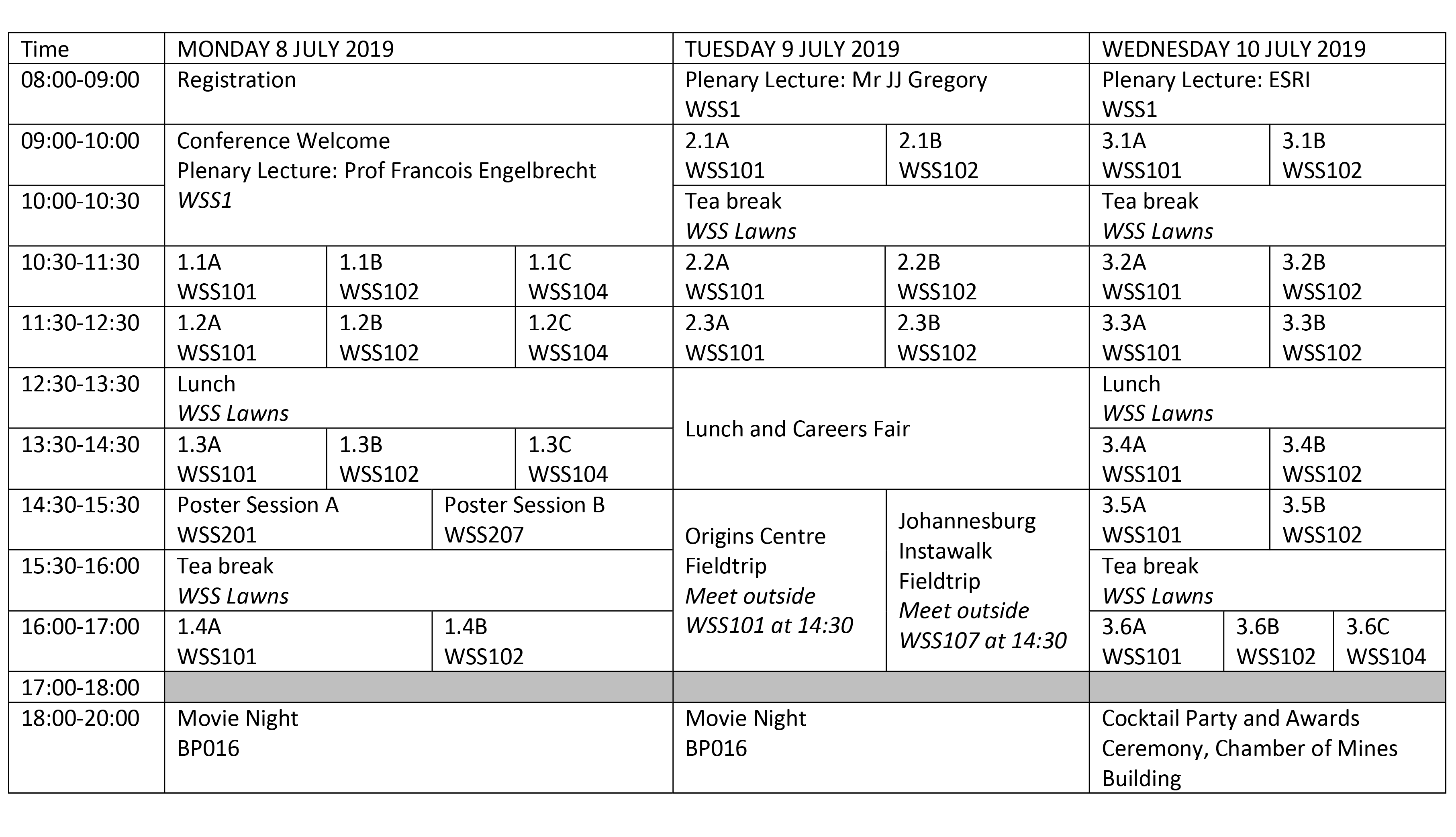
Abstract sessions
ORAL SESSIONS
Session 1.1A
- 147WS10: Investigating the impacts of water scarcity at Kwabhala
- 058WS01: Water Service Delivery and Alternative Water Sources in Selected Villages of King Sabatha Dalindyebo Local Municipality
- 146WS09: Investigating the impacts of water scarcity on community livelihood: A case of Qokolweni Administration Area, Mqanduli Eastern Cape, South Africa
- 086Z15: Analysing water scarcity and coping mechanisms in rural areas of Nongoma
Session 1.1B
- 029KZ02: Utilizing Image Texture combinations to detect and map Bugweed (Solanum mauritianum) an alien invasive plant within a commercial forest plantation.
- 087P05: Mapping Prosopis glandulosa (mesquite) in the semi-arid environment using remote sensing and machine learning algorithms: a case study of Prieska in the Northern Cape Province of South Africa
- 156WS12: Use of Geographic Information System to map deforested areas of the wild coast of Port St John’s.
- 030S01: Vegetation Degradation Caused By Military Training Exercises: The Case Study Of South African Army Combat Training Centre Lohatla
Session 1.1C
- 184CT07: Mapping the Food System: Towards a Multi-level Assessment of Food Systems Governance in Masiphumelele, City of Cape Town
- 123FS12: Food security among UFS students, a Qualitative study on the influence of food insecurity among young adults
- 188Z32: Investigating the collapse of KwaHlaza Farm Project in Nkwalini, KwaZulu-Natal.
- 155FS25: The Impact of Climate Change on Small-Scale Dairy Farming in the Eastern Free State Region of South Africa.
Session 1.2A
- 172CT01: Enterprising Refugees: The Case of Somalis in Cape Town
- 110Z22: Investigating African migrant informal enterprises in uMhlathuze Municipality: Nature, extent and policy response
- 107Z20: Analysing the Livelihoods and Lived Experiences of the Undocumented Migrants who Live in the Greenbelts of Richards Bay, KwaZulu-Natal
- 109Z21: Assessing the impacts of Chinese shops on South African retail shops in Stanger, KwaZulu-Natal
Session 1.2B
- 069Z08: Climatology of methane over South Africa using Atmospheric Infrared Sounder.
- 084Z14: The Influence of Winds and Temperature on the Ambient Air Quality Over Cape Town
- 113Z23: Time series analysis of sulfur dioxide and nitrogen oxides concentration in industrial towns at Mpumalanga
- 016W07: BTEX inhalation exposure: An investigation into the health risks and perceptions associated with runners in Bedfordview, South Africa.
Session 1.2C
- 137P07: Evaluating Student Motivation and Productivity during Mapathons.
- 114W20: Monitoring the Spatial Growth of Informal Settlements Using a Remote Sensing Technique in the Ekurhuleni Metropolitan Municipality.
- 132FS21: Exploring the use of satellite imagery for acquiring up-to-date spatial information at settlement level
- 099Z19: Performance of the satellite-derived Soil Moisture Active Passive (SMAP) sensor for remote sensing in KwaZulu-Natal Province
Session 1.3A
- 057P03: Exploring aspects of environmental sustainability in South African land restitution: The case of the Bela Bela community claim.
- 168Z30: The displacement and/or marginalization of people from their aboriginal lands in the creation of protected areas in KwaZulu-Natal, South Africa.
- 177CT03: Through the Eye of the State: The Land Claim-Conservation Dialectic in the Richtersveld
- 160FS26: Delving into QwaQwa’s Inevitable Environmental Injustice: The Spatial and Socio-Economic division in Rural Settings
Session 1.3B
- 098WS04: Remote Sensing and GIS approach for the water pollution and management in Umtata River
- 190NW09: Water pollution sources identification in the Mooi River catchment area, by integrating the RUSLE model with GIS.
- 130FS19: The effect of land use on water quality of Modderrivier, Central Free State
- 004J02: A GIS-based approach for the evaluation of land-use impact of future energy scenarios
Session 1.3C
- 153W22: The effect of lake water level decline on thermal stratification at Lake Sibaya
- 163WS13: Community Benefits on alien plants eradication programmes
- 040W11: Exploring household waste management processes: A case study of Brits Town, North West.
- 041FS02: Assessing the Spatial Extent of Illegal Dumping Sites in Maluti-A-Phofung Municipality: A Case of Qwaqwa Region
Session 1.4A
- 101NM05: The Impacts of Hydraulic Fracturing on Khoisan People's Sense of Place; in the Karoo Region, South Africa.
- 181CT05: Rendering the Suburbs Political
- 071S05: A geography of business parks in Cape Town
- 023J08: Student geographies and the night time economy: The case of Braamfontein, Johannesburg.
Session 1.4B
- 100W17: Accessing the use of remote sensing techniques to monitor the rehabilitation of asbestos mine dumps in Kuruman, Northern Cape.
- 049Z04: An analysis of the land rehabilitation programme of the Tronox mine: Environmental justice and the community of Gobandlovu
- 129FS18: Mine rehabilitation in the Free State
- 092WS03: Mitigation Measures and Rehabilitation Strategies for Sand Mining Activities: The Case Study of Port St Johns, Eastern Cape, South Africa
Session 2.1A
- 082WS02: Status of Solid Waste Disposal Practices in Informal Settlements: A Case Study of Mazakhele Informal Settlement in Harding, KwaZulu-Natal, South Africa
- 198S08: Utilising waste composition data to identify spatial relationships
- 192NW11: Understanding the waste-related issues within the Emfuleni Municipality: A governance approach
- 151WS11: Assessing the compliance of hospital on medical waste management in two selected hospitals: OR Tambo District Municipality, Eastern Cape, South Africa.
Session 2.1B
- 172W29: A Southern Hemispheric Tropical Cyclone Climatology: Analysis of Variability Under a Changing Climate
- 128FS17: Investigating summer temperatures in Bloemfontein, Free State
- 164FH02: Spatial distribution of rainfall characteristics on Sub-Antarctic Marion Island
- 191NW10: Characterizing climatology along the west-coast of Namibia
Session 2.2A
- 185CT08: Flood vulnerability and response at Bennde Mutale Community
- 142Z28: The Response of Dukuduku indigenous Forest To Severe Drought: 2015-2016
- 054W14: Evaluating the effectiveness of the responses to Cholera in Vhembe district, Limpopo .
- 161W25: Perceptions of Malaria Risk: Citizen Mapping of the Contemporary and Future Malaria Zone Boundaries in Southern Africa
Session 2.2B
- 200W21: An Analysis of Jacaranda Blossom Phenology in Johannesburg Over the Last Century
- 027WC03: Estimating the Potential for Natural Ecosystem Recovery at the Pietersielieskloof Wetland, Western Cape.
- 006J03: The Role of Local Communities Towards the Marula Trees (Sclerocarya Berrea) Conservation At Ha-Mashau and Ha-Mashamba Villages, Limpopo, South Africa
- 175Z31: The impact of climate variability in the spatial distribution of indigenous forests in KwaZulu-Natal, South Africa
Session 2.3A
- 178S06: Citizen-led hydro-resilience in Newlands, Cape Town
- 149WC05: Exploring the social aspect of environmental problems: Students' perceptions on the 2018 water crisis
- 134FS23: Google trends and water conservation awareness: the internet's contribution in South Africa
- 143WS07: Impacts of Climate change and Population growth on water insecurity
Session 2.3B
- 126FS15: When does spring start in Bloemfontein? A seasonal temperature study
- 141P08: Investigating drought in KwaZulu-Natal Province, South Africa using remote sensing and meteorological data
- 159W24: An analysis of snowfall patterns in the Eastern Cape Province using remote sensing images
- 116Z25: The land surface-atmosphere interaction effect the on temperature variation on the coastal area of Richards Bay.
Session 3.1A
- 013W05: Exploring travel agents understanding of tropical cyclone threats to tourism in the southwest Indian Ocean Islands.
- 018W08: Threats of extended dry periods to nature-based tourism in the Lowveld of South Africa
- 001J01: Climate change and snow-based tourism in Africa: The case of Afriski, Lesotho
- 062FS10: The potential of community-based tourism in Maluti a Phofung local Municipality, South Africa
Session 3.1B
- 037NM02: An assessment of hillslope and stream channel sediment connectivity in the Mgwalana catchment- Eastern Cape
- 133FS22: Geomorphological controls and hydrology of a peatland in an unchanneld valley bottom wetland in the Kgatswane Mountain Reserve, Rustenburg
- 131FS20: Gully erosion: The assessment of vegetation dynamics in the Ntabelanga Dam Catchment
- 127FS16: Description of seasonal interaction zones contributing water to main unchanneled valley-bottom peatland system in Kgaswane Mountain Reserve
Session 3.2A
- 090Z16: Assessing the living conditions in Section A, KwaMashu
- 072Z10: Assessing the Nature of Service Delivery Protests in Cato Manor, Durban
- 144NM06: Living near Shacks
- 028P02: Mapping Daily Struggles using Participatory GIS in Alaska Informal Settlement, South Africa
Session 3.2B
- 083Z13: Climate variability and it effect on the water availability in Goedertrouw, Midmar, and Pongolapoort Dam, in KwaZulu-Natal
- 1192Z6: Combined TRMM, CFSR and ground based measurements of precipitation: Validation over eastern region of South Africa
- 043FS03: Assessment of variation in wind speed and direction for establishment of wind farms within Maluti-A-Phofung municipality.
- 051W13: Using a venting systems as a mitigation strategy for methane gas reduction: A case study of Marie-Louise landfill site
Session 3.3A
- 125FS14: Species diversity change along a rainfall gradient in the Bloemfontein Karroid Shrubland, Free State Province
- 199S09: Eco-labelled honey harvested at selected farms in South Africa: The effects on conservation
- 115Z24: Evaluating the contribution of Indigenous Knowledge Systems to the Phinda Private Game Reserve environmental conservation programmes
- 017Z03: Assessing the impact of natural resource conservation on the livelihoods of the community of KwaNibela
Session 3.3B
- 065Z07: Evaluation of aerosols at Richards Bay Coal Terminal (RBCT)
- 007J04: Improving health risk assessments of PM2.5 from coal-fired power stations
- 193NW12: Assessing the state of PM and SO2 in a low-income settlement: A case of Zamdela
- 150Z29: The effect of meteorological parameters on air pollution around Richards Bay
Session 3.4A
- 061FS09: The Study of the Exclusion of Street Vendors during Urban Planning and its Impact on Setsing.
- 200WC06: The Philippi Horticultural Area (PHA) and the Right to the City: exploring transitional aspects of space and place
- 036NM01: An investigation into the application of the Land Redistribution Policy with regards to the resettlement of the community in Gertrudsburg, Limpopo.
- 089W16: Power relations between domestic workers and employers; an analysis of engagement with space
Session 3.4B
- 010W04: Holocene sea level fluctuation related to a geomorphic change in the coastal town of Yzerfontein.
- 183CT06: Governing the tides: The Case of Langebaan's Disappearing Shoreline
- 060FS09: Assessment of Environmental factors for dam storage capacity in a mountainous area - A case of Fika-Patso Dam, South Africa.
- 081KZ06: Predicting Soil Organic Carbon Stocks Under Commercial Forestry in KwaZulu-Natal South Africa Using Topo-Climate Variables
Session 3.5A
- 008W02: Coming From Afar: A Study Exploring the Mobility and Livelihoods of Rural Residents of Eshowe, KwaZulu-Natal
- 108WC04: Affordability, reliability and safety: The lived experience of public transportation in Cape Town, based on staff at the University of the Western Cape
- 207Z33: An assessment of rural transport and mobility in Manguzi (Thandizwe, Mahlungulu, Mfakubheka), uMhlabuyalingana Local Municipality
- 075P04: Creating a profile of Grade 7 learners based on their environmental knowledge, attitudes and behaviour: a situational analysis.
Session 3.5B
- 055Z05: Assessing Land Cover Change at Ezulwini and Matsapha Peri-Urban Areas, Kingdom of eSwatini between 1998 and 2018
- 111WS05: The Benefits of Renewable Energy Over Non-Renewable Energy- A Case Study Of Mqhele And Zandukwana Location.
- 124FS13: An Examination of the role of Heritage Impact Assessments in Environmental Impact Assessments from the Free State Province
- 194NW13: A quality review of waste management practices in PhotoVoltaic (PV) solar renewable energy Environmental Impact Assessment Reports
Session 3.6A
- 026WC02: Organisation of urban agriculture in Mitchells Plain, Cape Town
- 035FS01: Disaster (Un)preparedness: The case of cyclone Idai in Chipinge and Chimanimani.
- 044FS04: The Geography of alcohol use in Maluti a Phofung: the case of UFS Qwaqwa Students
- 140FS24: Contestations of urban settlement demolitions in Harare Metropolitan Province since 2013
Session 3.6B
- 003W01: Quantifying shifts in the timing of rainfall across South Africa for the period of 1987-2016
- 171W28: Statistical classification of South African Seasonal Divisions on the Basis of Daily Temperature Data
- 148FH01: Climate change adaptation and disaster risk reduction: policy, programme and practice for sustainable planning outcomes in coastal urban areas
Session 3.6C
- 196CT09: Enhancing farm management decision making through integrating seasonal forecast information and crop models
- 085FS11: Assessing the interface between natural and grazing ecosystem in the mountainous eastern Free State, South Africa: landscape approach
- 097P06: The potential of high resolution imagery for mapping small scale maize farms
POSTER SESSIONS
Poster Session A
- 047FS06: The Perceived Impacts of the Clarens Mountain Estate Gated Community on the Surrounding Area of Kgubetswana in Clarens, Free State.
- 021J07: Assessing the potential for producing energy from agricultural and forestry residue in the Ehlanzeni District Municipality.
- 078Z12: Analysis of underlying components that account for service delivery protests at Emncongweni,Eshowe in Kwa-Zulu Natal
- 091Z17: Exploring the lived experiences of informal cross border traders at Beitbridge border.
- 079NM04: The incorporation of Indigenous Knowledge in Disaster Risk Reduction of Floods in Port Alfred, Ndlambe Municipality.
- 059FS07: The Social Ecological Impacts of Fire at Umngeni Valley Nature Reserve
- 165WZ6: Gendered Perceptions of Public Transport Safety amongst Wits University Students.
- 118W21: Analysis of snow chemistry for the detection of air pollutants in the Drakensberg, South Africa
- 167NM07: The Era Of Solastalgia: A Social-Ecological Perspective on Psychological Distress and Community Resilience (The Elandskraal Wildfires Experience)
- 050W12: Water Scarcity and Quality in Ladysmith: Small Towns Matter
- 203J10: Formulating a Low-Carbon Plan for the University of Johannesburg
- 202J09: Electricity Grid Connection Concerns and Constrains: A case of Konkoonsies 2 Solar facility, Northern Cape
Poster Session B
- 204CT10: Investigating the physical and geochemical characteristics of the recent and modern sediments of Knysna estuary and Lagoon.
- 095Z15: Response of sugarcane production under the threat of drought in KwaZulu Natal sugar mills.
- 176CT02: Combining Google Earth and GIS techniques in quantifying gravel plain damages in the Central Namib Desert
- 122Z27: Analysing the impact of aerosols in rainfall formation in Richards bay
- 073Z11: The influence of ENSO on rainfall variability over southern Africa (1987-2017)
- 170W27: Age and Provenance of Pumice Debris at Yzerfontein
- 046FS05: Changes in Grasslands and other Land Use and Land Covers in Maluti-A-Phofung Municipality
- 038W10: Exploring challenges with BTEX emissions from fuel storage and potential BTEX reduction technologies: A case study of the Metrobus depot
- 154W23: Mapping land degradation in central-western Free State, South Africa, using Remote Sensing: a land use land cover change study.
- 014W06: Geodiversity and geoconservation in johannesburg: a comparative study of klipriviersberg nature reserve and melville koppies
- 205W22: An assessment of the climatic suitability of Afriski Mountain Resort for outdoor tourism using the Tourism Climatic Index (TCI)
- 063Z06: Impact of Atlantic Niño on the weather and climate of the west coast of Southern Africa.
- 007Z09: Spatio-Temporal analysis of vegetation rehabilitation in RBM using Landsat data
- 206W23: Exploring Spatial Variability in the Rivers and Streams of the southwestern Cape Region Through Diatom Analysis.
- 056KZ05: The retrieval of canopy level, biophysical attributes of emergent Yellowwoods in an indigenous Afromontane forest: The ‘Big’ Tree Analysis.
- 032K203: The utility of Sentinel-2 data to quantify and compare the variability of Cyperus dives and Typha capensis Leaf Area Index and Chlorophyll content between natural and rehabilitated wetlands.
- 180CT04: Heavy Metal Concentrations in Surface Sediment of the Zandvlei Estuary and Catchment